Svamitva - Empowering Rural Land Ownership through Photogrammetry
Indian Land Modernization
May 14, 2024
For years, rural land ownership in India has been plagued by disputes and confusion. The Indian government's Svamitva project aims to change that by creating a comprehensive land record system using modern technologies like RTK/PPK drones, and photogrammetry that documents ownership to potentially reduce land-related disputes.
Svamitva stands for Survey of Villages And Mapping with Improvised Technology in Village Areas, and covers almost all of the 660,000 villages in India. Along with individual properties, community assets like village roads, ponds, and open spaces will also be mapped under this project.
These maps are then used to create a modern land record system that empowers citizens to use their property as a financial asset for taking loans and other financial benefits. Moreover, they will help better determine property tax, establish a clear demarcation of boundaries between villages, and create a survey database to be used by any government department for sustainable land use planning.
Mahatma Gandhi once said “The future of India lies in its villages” and project Svamitva is definitely a step towards making it happen.
Svamitva is massive in scale
The Svamitva project, with a budget of over $75 million, aims to map India's 660,000 villages, each with an average area of 1.4 sq km (~350 acres). To accomplish this, the project requires capturing more than 1,000 photos per square kilometer, resulting in the collection and processing of over 1 billion photos over the course of this entire initiative.
(a) Orthomosaic (b) Elevation map including man-made features (c) Terrain map without non-ground features
By utilizing photogrammetry, the project aims to generate 3D maps of the targeted areas, similar to the ones presented above. Photogrammetry is a technology of extracting measurements from photos. These maps will offer precise measurements, streamlining decision-making processes and reducing the requirement for on-site visits to obtain information in the future. Upon completion, clear ownership certificates will be issued to the rightful owners.
The Ministry of Panchayati Raj has also started e-distributing property cards to rural homeowners who can access their property information and obtain a digital copy of their property card. The total number of villages that have been mapped and for whom property cards have been issued can be tracked live here.
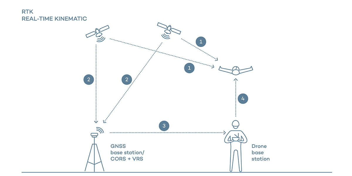
Enabling precision mapping with new-age technologies
Svamitva has set impressive accuracy standards, aiming for 5 cm GSD (Ground Sampling Distance) for measurement precision and 10cm horizontal and 20cm vertical for global accuracy. This means you can click on any point on these 3D maps and get its latitude/longitude within 10cm and altitude within 20cm. Moreover, even distances can be measured between points or compute areas with 5cm accuracy.
This is being achieved by utilizing RTK/PPK drones that collect photos with embedded GPS information with an accuracy of around 5-10 cm, and a network of CORS (Continuously Operating Reference Stations) stations that helps to further improve GPS accuracy. Around 730 CORS have been integrated with the control center.
Many people wonder why satellite images are not commonly used for the Svamitva project. This is due to the limited accuracy of most commercial satellite images, which are typically only precise within a meter. This can have significant consequences, especially when it comes to dealing with property boundaries.
Additionally, satellite images must be timed to capture specific remote locations which are not usually captured, which may not be suitable for other industries for commercial purposes.
Future scope
In addition to addressing property ownership issues, Svamitva has the potential to pave the way to a variety of modern applications and services. The project has led to the installation of a permanent CORS network, which will facilitate accurate data collection and mapping projects in the future.
In case the government opts to create an open source library of the surveyed villages data, private players can take advantage of the highly accurate data to develop geospatial intelligence applications effortlessly.
The Indian government is also working on mapping the urban areas to create highly accurate 3D digital twins. Why and how is this different from Svamitva? It will be covered in Preimage’s next blog. Stay tuned!
You might like this!
How AI is Revolutionizing 3D Modeling: From Videos to BIM
AI turns videos into BIM-ready 3D models in hours, making 3D modeling faster, affordable, and accessible with Preimage.


.jpeg)


